The small and picturesque hamlet of Sheepwash sits astride the River Wansbeck about one mile west of Ashington and four miles east of Morpeth. The crossing over the Wansbeck is made by way of a single-lane, traffic-signal controlled bridge.
.jpg) |
| Looking SW towards Sheepwash Bridge |
 |
| Google Map Location of Sheepwash (click to enlarge) |
The naming of Sheepwash would seem straightforward enough: a place where the sheep could be dipped to wash the wool and rid it of parasites prior to the sheep being taken to market. Presumably, in medieval times, some kind of enclosure was made across the river channelling the sheep through the water at just the right depth. The 19th century Ordnance Survey maps mark a fording point at this location, so it would seem to match the criteria needed.
 |
| 1st Ed Ordnance Survey c 1860 |
But then I read the entry from John Hodgson-Hinde's famous and revered "History of Northumberland". The volumes that make up the HON were published in the early 19th century. Hodgson-Hinde was the vicar of Hartburn. Throughout the article he refers to the hamlet as Shipwash. He must have been aware of the more usual pronunciation of Sheepwash for that is how it is recorded on all of the 17th - early 19th century mapping. And, it is likely, why he felt an explanation was needed as to the usage of the name Shipwash. This is what he wrote:
Of the parish of Shipwash (1), its boundaries, and the ecclesiastical institutions within it, little seems to be known. Its name does not occur in the list of livings within the county assessed to pay the fruits and tenths to the crown in 1291. In the minutes of the institution of Alexander Brown in 1548, and of Thomas Ogle in 1555, it is called the "rectory of Shipwashe." Besides the church there was a hospital here, to the custody of which, bishop Hatfield, 7 May 1379, collated John de Newthorpe, of Pontefract, it then being vacant by the death of William del' Orchard, its last master and keeper. But no remains of either church or hospital are now to be seen here excepting the basin of a large and beautifully formed basin of a stone font, which is used for a trough for the cattle to drink out of in the fold yard of the rectory. The parsonage house stands snugly and delightfully, and has the interest of beauty of its site very greatly enhanced by the winding and woody banks of the river, a fine old bridge of four arches, the mill of Shipwash, and the old mansion of the Bulmans, besides gardens, orchards and shruberies in "gallant trim" and full of beauty and luxuriance. Spitals, such as the one that which formerly existed here, were founded for the benefit of travellers, very commonly at the ends of bridges, or by dangerous washes or fords, or in passes in mountains.
(1) Small ships can come as far up the river as the bridge here, a circumstance which might occasion the name of the place, a wash having the same signification as a ford... "Washum in old Latin records, a shallow or fordable part of a river or part of the sea, as the washes at Lincolnshire" - (Phillips).
 |
| Extract from History of Northumberland Vol II, Hodgson-Hinde |
Hodgson was suggesting that the suffix, wash, could be synonymous with ford. We have already established through old mapping, even being marked on Speed's 1610 map, that Sheepwash was a fording point on the River Wansbeck. But could small ships come this far? I made a visit to Sheepwash and noted that the river was quite shallow at this point and only the smallest of boats could sail this far upstream. However, OS indicate that Sheepwash is the limit of the tidal River Wansbeck and I may not have been observing the river at its highest level. I also noticed a weir, cutting diagonally through the river, just west of the bridge. This suggested that the flow of the river had been artificially altered at some stage in the past. The same OS map which marked a ford at this location also showed a corn mill, which no longer exists. The power to drive the corn mill came from water channelled, via the weir, through a mill race, of which there is also no trace remaining.
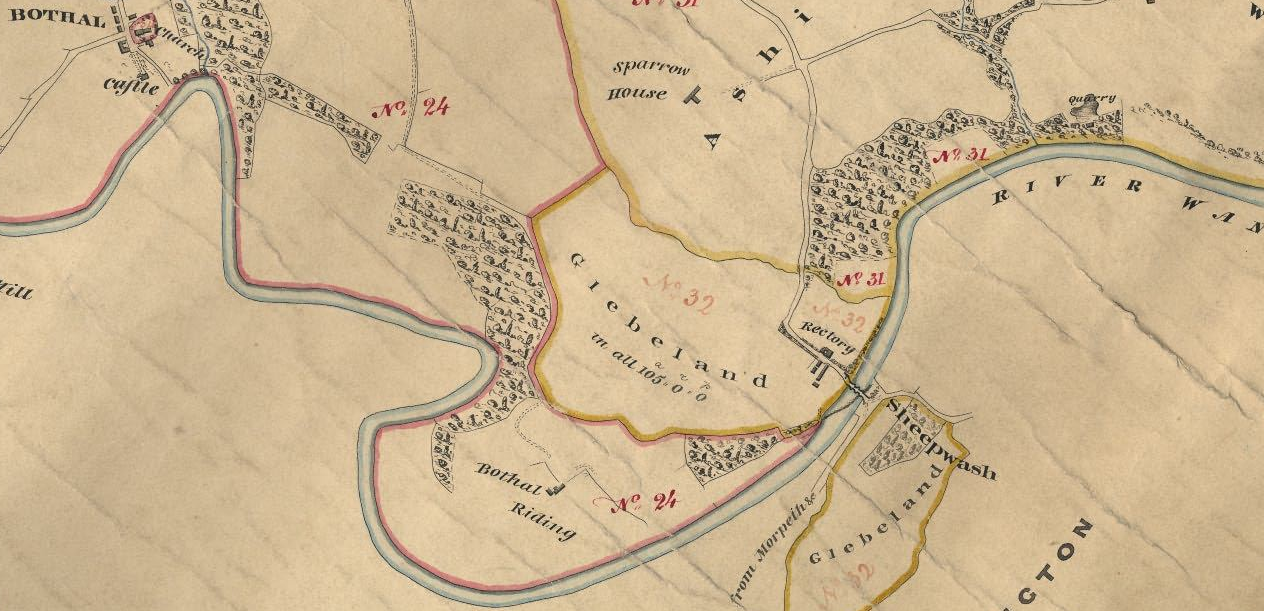
 |
| 1830s Tithe Map (click to enlarge) |
But even if the river was deep enough for small ships why would it have been significant to add wash, or ford, as a suffix to ship? My guess is that Hodgson may have been wrong in his assumption. The Oxford Popular Dictionary of English Place Names lists a settlement in Devon named Sheepwash and gives the explanation as: a place where the sheep get dipped.
 |
| John Speed Map 1610 Indicating a Ford at Sheepwash |
It is clear from Hodgson that Sheepwash was a small but significant settlement in pre-industrial times. The Rectory house of the late 17th and early 18th centuries still exists. Pevsner, in the "Buildings of England" series describes a "spectacular ceiling" within the dwelling. A large number of burials discovered in 1988 just opposite the Rectory, and immediately NW of the bridge, indicate that the long since demolished medieval church was located here. The font mentioned by Hodgson is now located in the grounds of Bothal church. Remains of the medieval bridge can still be found.
.jpg)