 |
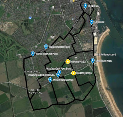
| To view this as a stand-alone interactive map click here... Blyth Farm Map |
The farms seen here had probably come into existence during the early 17th century or even during the late 16th century. There are documents of rental from the late 17th century which show individual farms to be in existence and probably close to the same ones shown on this map, but with different names at that stage. Cowpen farms, to the North of this map, came into existence in 1619.
In the Middle Ages townships such as South Blyth and Newsham consisted of large open fields divided into strips and farmed in common between the peasants. By the 16th century this method was not conducive to an efficient system of agriculture. Landholders sought to consolidate their holding into one single block. They would enclose this holding with hedges around the boundary and individual fields.
Blyth was owned by one single landowner during the early-modern period: first the Cramlington family, then the brother of the Earl of Derwentwater and in 1723 the Ridley family of Blagdon. This meant the creating of individual farms for rent was a much easier process than when several landowners had to negotiate a division between themselves and why I believe enclosure may have taken place earlier than 1619. Considerable amounts of this farm land have now given way to urban development. Approx 1178 acres in total for the township.
Wagon Way West Farm
194 acres. 9 fields. Tenanted 1785 by Timothy and Joshua Dukesfield.
Replaced by housing and a railway by the 1860s.
Newsham West Farm
120 acres. 10 fields. Tenanted 1785 by Timothy Dukesfield Jnr.
Disappeared off the maps by 1897. The colliery village of South Newsham was built on the farmhouse site. Some of the lands were probably absorbed by the newly-formed South Newham Farm.
Newsham Middle Farm
114 acres. 8 fields. Tenanted 1785 by Joseph Clarke.
By 1897 replaced by Newsham South Farm which probably also incorporated Newsham West Farm.
Newsham East Farm
130 acres. 10 fields. Tenanted 1785 by William Bennett.
Marked as Newsham Low Farm on the 1st Edition OS map of 1860s. Known in modern times as North Farm.
Wagonway East Farm
143 acres. 11 fields. Tenanted 1787 by John Watson.
Marked as Low Horton Farm on 1840 estate survey and known as Barrass farm on 1860s mapping and thereafter. By 1924 the triangular nook to the North of Plessey Road was occupied by a school. Replaced by housing and a garage by 1960.
Link Farm
166 acres. 10 fields. Tenanted 1787 by Ellstob and Hogg.
Gone by the time of the 1924 mapping. Replaced by Wellesley site and allotments.
Blyth Farm
Tenanted 1787 part by Mrs Marshall and part Clarke and Watt.
Largely completely built upon by 1895.
Link House Farm
Belongs to Nicholas Ridley (a junior member of the main Ridley family of Blagdon)
154 acres. 14 fields. Tenanted 1787 by Margaret Dobson.
Buildings are still standing although fell out of use as a farm in the late 20th century.
 |
| Ancient hedges still in existence at South Beach which one marked the boundary between Newsham East and Link House Farms |
