29.4.13

Hartford Quarry House

Hartford House Location (click to enlarge)


Enjoying a stroll through Plessey Woods Country Park, as many of us will have done, I found myself surrounded by vertical, towering rock as I meandered along the Pegwhistle Burn. Quite clearly this was a former quarry, but strange cuts in the rock, stretching the full height of the 40ft cliff, just below the Morpeth Road, caught my eye.

The 1st and 2nd editions of the Ordnance Survey mapping from the mid - late 19th century confirmed this to be the site of a quarry. The OS maps also clearly show a building to be in existence at the location of the unusual rock markings. Could this have been a building used for storage or even a dwelling that used the face of the quarry as one of its walls?

This newspaper article from 1859 is titled "The Smallest House in England":
What I have long known as "The Smallest House in England" is in Plessy Woods, the charming summer home of a Newcastle man of business. It has the charming woods all around it, and the "Well of St Keyne" at its door. As I have said it has the dimensions of a ship's cabin; and perforce of skilfull arrangement, the comforts of a mansion house.
 Janet Bleay in the booklet  "Plessey: The Story of a Northumbrian Woodland" elaborates:
On the quarry wall you can see square holes at two levels which supported the floor and ceiling beams. This cottage was lived in until after WWII and the people kept a sweet shop which was entered from the side door off the Morpeth road. The coal shute is still there in the wall by the road. The cottage by the Pegwhistle Burn was small and it is just possible that this was the one described in the newspaper article.
Ordnance Survey c1897

The 1841 census revealed Thomas Fryer (no relation) a quarryman and his family residing at Hartford Quarry House. William Watson, a cartman, and his family were also resident. There was, however  more than one cottage in the vicinity of the quarry and this may have not been the "Smallest House in England" although it may not have started out as a three-storey building, that it clearly must have been at the time of it being a sweet shop. It may have had a vertical extension at some stage of its life. These 1899 auction notes describe it as:
Built on the edge of an old quarry and the top storey, which is accessible from the road, contains four rooms and pantry with out-offices; the lower offices which are alone accessible from the quarry, are at present used for dog kennels and store rooms.
This was clearly an unusual and interesting building the use of which changed during its lifespan. The quality of Hartford stone from the quarry was highly valued. A newspaper article of 1859 mentions that the stone was used in the repairs to the Houses of Parliament and two London bridges.

23.4.13

The Blyth Isabella Pit Early Days

Site Location (click to enlarge)


This one is a bit self indulgent, being from the place I have called home for eighteen years: the former Isabella Colliery village within Blyth.

The Durham Mining Museum website lists the beginning of the sinking of  Isabella Colliery as the 30th October 1848. At its most productive in the 1930s the colliery employed 917 men. Coal was first deep mined in Cowpen in 1793 by a partnership of speculators that would eventually become the Cowpen Coal Company. This is from the Northumberland County Histories:
In 1840, the Cowpen owners took the coal under the properties of Messrs. M. J. F. Sidney and William Harbottle at Cowpen, on which they sunk the Isabella pit in 1848, to open out the Low Main at a depth of 1 1 1 fathoms. They connected it with the railway, which had, in 1847, been made by them between Blyth and Hartley for the purpose of securing an outlet to the Tyne along the line constructed from Seghill to Hay Hole in 1840, and subsequently extended to Hartley, the whole system forming the Blyth and Tvne Railway.

1st Edition OS of Isabella Colliery c1860
However, even by the time of the 1st edition Ordnance Survey map of c1860 only four houses are shown at the colliery. So what was happening in these early days? Where were the miners? I turned to the 1851 census for answers. The four dwellings at the "New Cowpen Colliery" were occupied by John Kettlewell a master sinker, age 51, born at Haltwhistle, his wife and 3 children, the eldest son also being a sinker. A lodger also resides at the house, once again a sinker, age 28, born in Westmorland. Next door lives John Coulson, an engineer, with a wife an daughter. The next houses are occupied by Edward Maughan and John Brewis and their small families. Both are enginemen. These men were highly skilled and were involved in the technical management of the colliery. A master sinker could earn more than twice that of a coal hewer, his wages alone being 15% of the sinking expenses, and sinkers were usually not an employee of the coal company but a contractor. So, had the pit sinking actually been completed in the 1850s? The mine would have been operational by this time. The ordinary mineworkers' accommodation had already been established at Cowpen Quay to house the workforce of the Cowpen Coal Company and most miners would have walked the half a mile to the new colliery from here. Only three sinkers are resident at the colliery by 1851. The main sinking would have involved a team of a dozen men or more. Kettlewell and his small team would have been overseeing the maintenance of the shaft and further sinkings down to lower coal seams. This is from "Ford Mason, Peter (2012-08-31). The Pit Sinkers of Northumberland and Durham":

With the establishment of the pit villages, generally in remote places, the first to be housed were the shaft sinkers, followed by the jerry builders who erected the long rows of one-up, one-down cottages, to house the incoming miners.  With sinkers employed at the opening of a colliery, their accommodation consisted of small stone cottages built from the first stone raised from the pit shaft as it was being sunk. The line of cottages were often called Stone Row or Sinkers Row. The sinker rows were often much larger and commodious than any of the other colliery stone cottages, although still small to accommodate a large family. As progress was made towards the full operation of the pit, permanent colliery housing was built and eventually the sinker huts were replaced and the ‘raws’ were taken over by the colliery owners.
Having housing nearby to the Isabella Pit the colliery owners probably did not feel so hurried to construct dwellings for their workforce, although this had taken place by the time of the 2nd edition Ordnance Survey map of c1897. This map shows eight dwellings on what was to be later named North Row. The original sinkers and engineers houses are clearly larger and more "commodious" than the four later additions to the row. North Row was demolished by the mid 20th century and so far I have been unable to trace any existing photographs of the housing.

Isabella Colliery c1897 2nd Edition OS Map
A relative of a former resident of North Row informed me recently that even in the latter days of the housing it was still the accommodation of the men more involved in the maintenance and essential operations of the colliery.
Beginning the Shaft at Ellington 1912
Sinker Protective Clothing


15.4.13

Bothal Deer Park


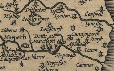
Location of Deer Parks on Speed's Map (click to enlarge)


John Speed's 1610 map of Northumberland is cartographically immature as compared to the accuracy of modern-day maps. No roads are displayed and settlements are displayed as symbols. Features that are prominent, however, when looking at the South East Northumberland section of the map, are fenced enclosures around such places as Bothal, Cockle Park and Mitford. These villages had a greater importance in the middle ages than nowadays, being the centre of the estates of important landholders and the location of their castles. The enclosure at Bothal appeared to cover a huge area on Speed's map, possibly even the size of the whole estate.


John Speed 1610 Map of Northumberland (part) 

Recalling my history lessons I remembered that the gentry enjoyed hunting and parks were often made for this exact purpose. I suspected they were medieval deer parks. But was this the case? Who commissioned the parks and why? How large were they? How was the land used within it and how did this alter the management of the estate at Bothal if it did cover all of the available farming land? Were they really enclosed by a fence? The term "park" still occurs on some features shown on modern mapping. Surely this was a clue to the former land use?

The main landholders of Bothal during the Middle Ages were the Bertrams. This is from a Wansbeck District Council planning document of 2008:

The Bertrams were Lords of Bothal from the late twelfth century until 1406. It is thought there was a building on the site of the present castle by around 1150, known as a manse or mansum (nothing of which survives) and likely to have been fortified before the Norman Conquest. It was not until 1343 that Robert Bertram IV, high sheriff of Northumberland, was given a licence to crenellate.
According to Richard Lomas in his book "North East England in the Middle Ages" thirty-six of these parks have been identified in Northumberland, and although more research needs to be done in this area, they were created between the beginning of the twelfth and middle of the thirteenth centuries. Most parks were between 100 - 200 acres in size, although Hulne Park, created at Alnwick by the Duke of Northumberland, is larger.

To establish a deer park a Royal licence was required. Because of their cost and exclusivity, deer parks became status symbols. Since deer were almost all kept within exclusive hunting reserves used as aristocratic playgrounds, there was no legitimate market for venison. Thus the ability to eat venison or give it to others was also a status symbol. Consequently, many deer parks were maintained for the supply of venison, rather than hunting the deer.
The landscape within a deer park was manipulated to produce a habitat that was both suitable for the deer and also provided space for hunting. "Tree dotted lawns, tree clumps and compact woods" provided (pasture) over which the deer were hunted and wooded cover for the deer to avoid human contact. The landscape was intended to be visually attractive as well as functional. [Wikipedia]
The park was according to Lomas a securely enclosed area by means of a ditch and bank and stone wall or quickset hedge. Nationally, it would appear that a palisade fence was often used to surround the deer park, but in the North stone walls were the most common method. Speed may have used a common fence symbol in all his mapping of Great Britain for reasons of uniformity.
 
Fortunately the owners of Bothal in 1632 commissioned a survey and had a plan made of the estate. At first glance it looks like most maps of the time: a mere sketch. But overlaying this on to modern satellite photographs it is surprisingly accurate. And, the estate does not appear to have altered greatly over a four-hundred year period. Bothal Park corresponds almost exactly with the modern-day Park Wood. This is only 1.1 miles in circumference and takes only a fraction of the estate leaving plenty of land for arable use. Speed, on his map, had given Bothal Park a greater prominence than it deserved. The woodland still remains today uncultivated and can be enjoyed by walkers.