Boundaries and Areas
From the middle ages until the late 20th century the administration of various services etc (mostly poor relief) was carried on through the church network. Churches administered an area called a parish. the parish was further subdivided into areas called townships (named vills in earlier times).
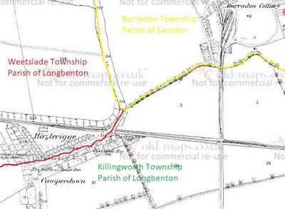
Burradon Township was part of Earsdon Parish. The village we now know as Camperdown was in Longbenton parish but the North of the road was in Weetslade township, the South side was in Killingworth Township. The colliery was built in Burradon but for reasons yet to be fully established the owners established the colliery housing across the border in Longbenton parish. The boundaries were demarcated by streams that have since been filled in by the colliery track and main road (although a section of ancient stream can be found past the railway bridge towards Weetslade).
Weetslade had been owned by the Hazlerigge family since 13th century and the settlement was therefore called Hazlerigge. But a name was needed for the shops, pubs and housing that was springing up on the South side of the road in Killingworth Township. The four and twenty of the parish (like your modern-day councillors) decided on the name Camperdown, although we do not have the documentary evidence of this. But... "1840 Aug 06 - A baptism recorded in the register of Longbenton, St. Bartholomew gives the first recorded reference to the name Camperdown as a settlement. "William to John and Mary Cockburne of Camperdown, pitman."
The 1906 Kellys trade directory list "Hazlerigge is locally known as Camperdown" and by 1910 the name Hazlerigge has been dropped officially altogether. At around this time the boundary between Burradon and Camperdown is moved from the colliery track (ancient stream) to the Seaton Burn Wagonway rail line.
 |
| Seaton Burn and Sandy's Letch |
 |
| Boundaries, Streams and Field Names of Burradon from 1804 Estate Map |
 |
| Sandy Letch NE Burradon Boundary |
 |
| Boundary Stone at Seaton Delaval where Seaton Burn and Sandy's Letch meet |
1804 - The area of Burradon township was 535 acres 2 rods and 26 perches (the acreage seems to have remained at around this figure throughout the middle ages).
1839 - Hillhead farm 183 acres 3 rods and 32 perches.
1861 - According to the census of this year Hillhead farm consisted of 175 acres.
1897 - Burradon township consisted of 545 acres an increase on the 1804 figure. A presumption can be made that Burradon township had encroached into Hillhead farm.
1906 - Burradon township 547 acres. Hazlerigge estimated to be 132 acres.
1905-1912 - The areas would have changed dramatically around 1912 when the boundary between Burradon and Camperdown was moved to the line of the Seaton Burn waggonway. Later in the 20th century a new settlement of Fordley was built on the lands in the north of Burradon township.
Ecclesiastical
Burradon was in Tynemouth Parish and the parochial chapelry of Earsdon. Camperdown was in Longbenton Parish.
1865 - Killingworth parish was formed out of Longbenton and Camperdown became part of thois new parish.
1860s - The new primitive methodist chapel (still extant as a dwelling house) was part of the Seaton Delaval methodist circuit.
1892 - Burradon was separated from Earsdon parish and added to Killingworth.
Parliamentary
Burradon was in Wansbeck constituency, Killingworth and Weetslade in Tyneside constituency. At sometime between 1904-31 both Burradon and Camperdown became part of Wallsend constituency.Administrative Areas
X 1166 and throughout the middle ages - Burradon township was a separate part of the Barony of Whalton. The lands of Camperdown were part in Weetslade township and part in Killingworth township. Both townships were part of the Barony of Merlay and in Castle Ward.
1888 - A local government board act was passed which required the setting up of urban and rural district councils. Camperdown was included in Weetslade Civil Parish which was formed out of Longbenton Civil Parish.
1899 April 01 - Camperdown became a civil parish in its own right which was the smallest unit of public administration. It was part of the Tynemouth Rural District which administered such things as implementing public health acts.
1912 April 01 - A local government board order came into effect on this date - Number 56,450. Longbenton, Burradon, and Camperdown Townships were united as Longbenton Civil Parish. The Civil Parish eventually became Longbenton Urban District council.
